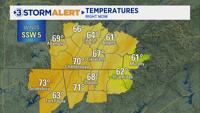


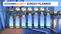

Happy Sunday! We are kicking off our weekend with temperatures in the 40s under mostly cloudy skies. Areas of patchy dense fog will be around this morning, with visibility dropping below a quarter mile at times. A Dense Fog Advisory will remain in effect for most of the area until 9 AM. Temperatures will rebound into the upper 60s this afternoon with partly cloudy skies.

Monday will remain dry, with warm temperatures reaching the lower 70s.
Unsettled weather will return to the Tennessee Valley Tuesday as low-pressure tracks across the Southeast. Periods of rain will break out during the morning and continue through Wednesday morning. The remainder of the week will remain active, with another round of showers returning Friday into Saturday. 2-5" of rain will be possible through this weekend.
For the latest, download the Local 3 Weather app.